YARIS platform
Discover the YARIS platform
It contributes to the maritime domain awareness (MDA), maritime crisis management, and facilitates the legal aspects of evidence. Thanks to YARIS, the Gulf of Guinea’s maritime stakeholders have a secure tool to combat the threats to the blue economy.
Fundamentals
How was YARIS born?
YARIS was born in response to the principles enshrined in the Yaoundé Code of Conduct to improve the maritime safety in the Gulf of Guinea: maritime information sharing, interoperability and pooling of resources, harmonization. Specifically, Article 2.3 of the Memorandum of Understanding establishing the ICC states:
2.3. Request ECCAS, ECOWAS and the GGC to strengthen the activities aimed at cooperation, coordination, pooling and interoperability of resources between the Member States by:
[a) b) c) …];
(d) Establishing a common mechanism for sharing information and intelligence;
[e), f)].
The European Union has decided to support the Code of Conduct and its operationalization as part of its strategy for the Gulf of Guinea. It has initiated a range of capacity-building programmes and projects, including the GoGIN project. Find out more.
Who is YARIS for?
Originally, YARIS was intended for the centres that comprised or should comprise the Yaounde Architecture: 3 regional centres; 5 zonal centres; 19 national operational reference centres, for a total of 27 centres.
In response to requests from the Yaounde Architecture Member States, and from several partners, access to YARIS has been extended to various national administrations and external partners.
At their annual symposium held in Pointe-Noire, in November 2021, the Chiefs of Staff of the Navies of the Gulf of Guinea invited, in their final communiqué, “the naval staffs to continue the deployment of the YARIS system as a platform for sharing national, zonal or regional maritime information”.
What is YARIS for?
To secure the maritime areas, one must first monitor the ocean. This surveillance starts along the coastline and goes as far as one is able to gather data. This is known as “strategic depth”, which makes it possible to plan, prepare and coordinate actions to fight maritime crime in the best possible way. The further one watches out at the sea, the better one will know the maritime domain and the more one will be able to anticipate and act effectively to prevent or limit the consequences of a maritime event on the coast.
Criminals do not know maritime borders, which require appropriate responses, beyond borders. As no single State can cope with these threats by itself, a comprehensive approach to information exchange and inter-State coordination is deemed necessary to carry out actions at sea. The spirit of maritime community is imperative.
This is the raison d’être of the YARIS system: a controlled and secure computer network for sharing information that materializes and unites this maritime community. This allows the authorities to better understand the maritime domain in order to secure and protect it for the purpose of develop the blue economy.
What are the functions of YARIS?
YARIS comprises several functionalities covering the full spectrum of functions deemed necessary for the implementation of maritime safety and security. YARIS makes it possible to perform:
- maritime surveillance through the automatic detection of suspicious situations or behaviours on the basis of alert criteria;
- instantaneous or prospective analysis through the use of historical and statistical data on the situations found;
- planning and coordination of naval operations both in the setting up of an operation to combat maritime crime and in the management of a maritime crisis. The continued responsibility of the authority in the conduct of operations is also ensured through the platform;
- automatic and forgery-proof recording of the observed facts, allowing support for the legal aspects of an event.
What is the structure of YARIS?
The core of YARIS is organized into three modules that allow the implementation of the operational above-mentioned functions: Mapping module, Log module, Chat module with the possibility of creating confidential and partitioned discussion rooms.
YARIS also offers a secure work environment (YAMSA – Yaoundé Architecture Maritime Security Awareness), including email messaging, instant messaging, videoconferencing (according to authorization), shared files, and portals for centres. The members of the community benefit from a community intranet network to secure work and exchanges on a daily basis.
Content of the Mapping module
This function allows, through specific layers, access to a database, to superimpose the operational situation recognized in real time (from the sources of information inserted into YARIS) and the general knowledge of the theatre of operations (particular zones) while generating automatic alerts. It also allows the sharing of the maritime picture between the different stakeholders involved.
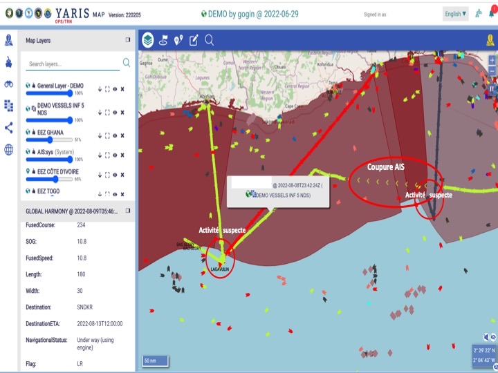
Caption: example of a maritime surveillance mapping
Content of the Logbook module (Log)
The logbook allows the official and forgery-proof recording of the course of events (legally enforceable).
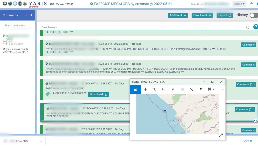
Caption: example of a MEGALOPS exercise carried out in the CRESMAC zone
Content of the Chat module
The Chat function allows the communication between the different stakeholders involved. The chat rooms are secure and vary in size depending on the members one wants to invite.
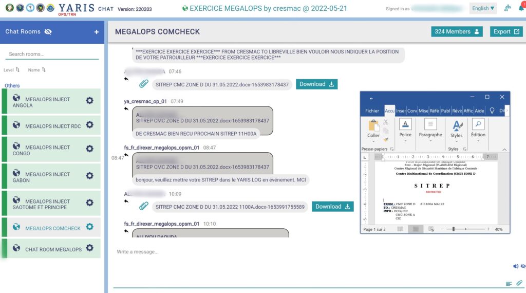
Caption: example of a chat during the MEGALOPS exercise
What data may be visible on YARIS?
YARIS is a system for aggregating information from different sources. This is how it is able to integrate data from several types of sources: AIS, VMS, radars, maps, satellite data, etc.
How is the security of the YARIS platform ensured?
In the YARIS environment, information security and cybersecurity are ensured by the following security measures:
- the identification of all stakeholders, applications, platforms, networks, data flows, external systems and services dedicated to users;
- the ongoing assessment of risks, in particular in the face of cyber threats;
- the access control of the network and information systems;
- the protection of data circulating in YARIS;
- the segregation and monitoring of different environments (operations and training);
- the continuous monitoring of networks and information systems;
- the ability to respond to incidents.
How is the training organised on the YARIS platform?
The training is done through a dedicated platform, identical in terms of functionalities to the operational platform but reserved for training and demonstrations. The training is carried out online or face-to-face, depending on the objectives. It is supported by multilingual teaching materials (French, English, Portuguese).
Who pays for YARIS?
The GoGIN+ project covers all costs related to YARIS until the end of the project (development, training, hosting, customer support, subscription to data sources).
The transfer of YARIS to its future owners will be free of charge, but they will have to bear all the operating costs.
MDA
What is the MDA?
Maritime domain awareness (MDA) is defined by the International Maritime Organisation as the effective understanding of anything associated with the maritime domain that could impact the security, safety, economy, or environment. MDA is said to work as a ‘key enabler’ for other maritime security issues, such as anti-piracy patrols, in the way that in order to do effective patrols you need to have the ability of conducting effective MDA.
The maritime domain is defined as all areas and things of, on, under, relating to, adjacent to, or bordering on a sea, ocean, or other navigable waterway, including all maritime-related activities, infrastructure, people, cargo, and vessels and other conveyances.
How does one share information?
Information sharing is paramount in the context of MDA and the control of a State’s maritime areas.
This sharing can be done in many forms, from the simplest (telephone, WhatsApp, emails, etc.) to the most complex (dedicated secure networks, ad-hoc software).
Actions using simple patterns are not very reliable and cannot provide a complete maritime picture. They can therefore lead to misinterpretation, with significant operational impacts.
In contrast, dedicated networks, thanks to the functions they offer (complete maritime image, map sharing, chat, documents, emails, videoconferencing, etc.) allow all stakeholders to quickly obtain a good picture of the events that occur. This allows the authorities to make good decisions and provide clear guidelines. dedicated networks, unlike simple sharing, require trained staff and good technical and operational structures.
What is the YARIS' contribution?
YARIS makes it possible to share maritime events (maritime picture, documentation, log, photographs, recordings, etc.), whatever it is, with the centres or subscribers selected by the sender of the information.
Thus, the centres of the nineteen Yaounde Architecture States can maintain a complete maritime picture and reflect the operational situation of their maritime areas, such as those of the Gulf of Guinea.
Another contribution of YARIS is the ability to aggregate data from surveillance systems and filter it as needed to automatically identify suspicious behaviour.
Crisis management
What is a maritime crisis?
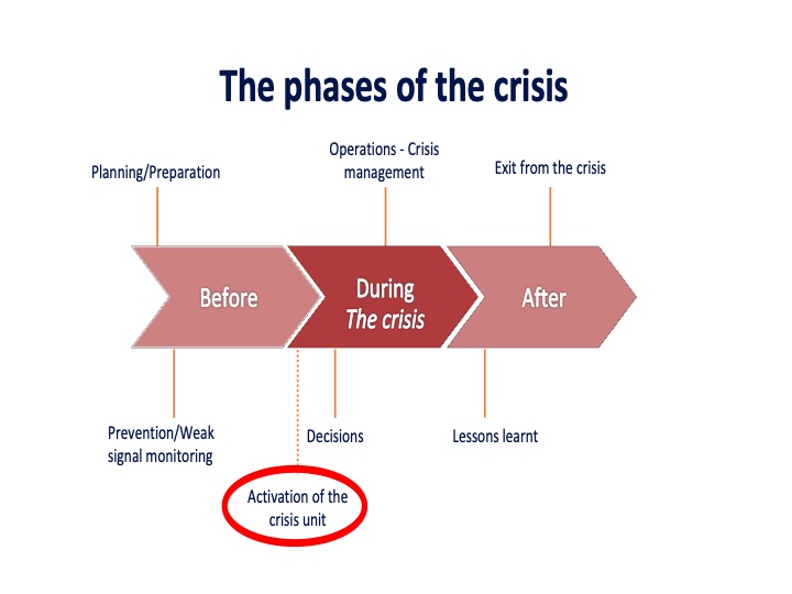
A maritime crisis is an unforeseen, brutal event occurring in the wider maritime domain and having a negative impact over an organisation. This event can have disastrous consequences in human, material, environmental or image terms. It is characterized by three major periods – “before, during and after” -, of variable intensity and duration.
During the period “before”, the crisis is marked by planning and preparation, the period “during” is the phase of conducting the crisis, finally the period “after” is the time of return to normal situation and exit from the crisis.
The examples of a maritime crisis are numerous and diverse:
- Collision between two vessels
- Large-scale maritime pollution
- Explosion in a port
- Taking of hostages on a ship
- A fire on a ship
- Shipwreck, etc.
How does one respond to a maritime crisis?
The maritime crisis is characterized by an imbalance between response needs and the resources available to address them.
The occurrence of a maritime event requires the establishment of a crisis organisation adapted to the intensity of the crisis in terms of human, material, operational, legal and financial resources. This crisis organisation must be prepared and planned in order to launch the first actions quickly.
This maritime crisis organisation shall comprise at least a crisis directorate and a co-ordination staff itself divided between a think-tank and an operations command centre. Each stakeholder in the crisis organisation can be bound by the YARIS system.
How does YARIS contribute to decision support in the conduct of operations?
The YARIS system allows to quickly connect all the stakeholders of the crisis, regardless of their geographical position. The crisis organisation, the stakeholders involved in the crisis, the list of alerts, the processes for connecting to YARIS, etc., must be prepared and planned. Crisis management can thus begin without wasting any time.
The YARIS system enables all stakeholders to acquire, through advanced analysis, in-depth knowledge of the maritime domain to plan, decide and conduct operations, at all levels, from the routine situation to the crisis situation, in order to ensure maritime safety and security in the Gulf of Guinea. This is done by collecting, processing, fusing and disseminating information of maritime interest while controlling its sharing and by establishing and maintaining a database of the maritime domain and adjacent bodies of water (ports, lagoons, etc.).
More than a tool for sharing maritime information, YARIS is an all-in-one tool that provides real decision support.
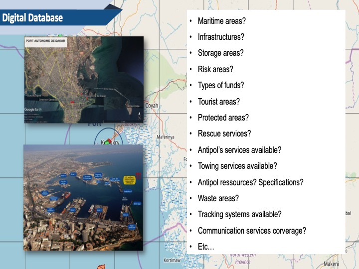
YARIS as a digital maritime database
YARIS includes a database that takes into account all the data deemed necessary for the knowledge of the maritime domain and the conduct of operations, for each centre. Example:
Legal aspects
Why is the judicial component important?
The countries of the Gulf of Guinea are gradually acquiring important leadership bodies and legal frameworks in the areas of maritime security and safety, as well as in the blue economy matters. However, drafting legal texts on a large scale is complex. Their effectiveness requires the commitment of all stakeholders. This involves many challenges, including the:
- strengthening of interstate cooperation and interactions;
- convergence and harmonisation of legal bodies (in particular the creation of a regional legal framework to combat maritime crime);
- implementation, at the national level, of international treaties and agreements relating to the fight against crime;
- adoption of robust and effective national legislation and regulations;
- strengthening the action of the State at sea;
- strengthening of the administrative and legal capacity and performance of the States (investigation, prosecution).
How does YARIS support the judicial component?
The YARIS system provides reliable and actionable electronic evidence in legal proceedings through its ability to capture forgery-proof information. In this context, and in collaboration with UNODC, fictitious courts are regularly organized to train magistrates to make better use of the data provided by YARIS.
Blue economy issues
What are the economic and security challenges of the Gulf of Guinea?
The economic challenges of the Gulf of Guinea are very important both for the inhabitants of the African continent and for Europeans and other external countries. 92% of goods arriving in or departing from Africa are transported by sea. Access to international markets requires maritime routes that need to be secured. Nearly 4,000 commercial vessels pass through the Gulf of Guinea every day, to which must be added fishing canoes, passenger transport, coasters, etc.
The Gulf of Guinea is also one of the richest areas in fish species, while two-thirds of the world’s population feed on fish. It is also a supply area for hydrocarbons (200 million tonnes exported each year), minerals, wood or cocoa. Finally, drug trafficking regularly uses a maritime route from South America to Europe, via West Africa.
Another challenge is the protection of the maritime environment and fisheries resources. The Gulf of Guinea receives nearly 3,000 tonnes of oil spills at sea each year. This pollution, combined with overfishing and illegal fishing, has major consequences for the population as it fuels maritime insecurity and significant migratory movements to more attractive regions.
The threats linked to the security of maritime areas are therefore much wider than the Gulf of Guinea alone.
What is Europe's importance in securing the Gulf of Guinea?
Since an agreement to synchronise deployments, Spain and Portugal have almost doubled their presence: almost 200 days at sea, per year, in the Gulf of Guinea. France remains the only European nation permanently present in the Gulf of Guinea since 1990 (Corymbe mission). The other partners deploy more occasionally.
In 2016, United Kingdom & France created an alert tool for the maritime industry that will eventually be taken over and installed on the African continent (the MDAT-GoG, Maritime Domain Awareness for Trade – Gulf of Guinea).
At the European level, there is a real political commitment. The European Union has defined a strategy for the Gulf of Guinea, and supports a large number of initiatives, notably through the Coordinated Maritime Presence (CMP) of European assets in the Gulf of Guinea and the GoGIN project, which support the development of the Yaounde Architecture and the development of the YARIS maritime information-sharing network.
What is YARIS' contribution to countering illegal fishing?
Fisheries is a vital economic and social challenge for Africa. It is a resource that is plundered. This sector is an essential part of the dietary balance (protein intake) of the populations of the coastal States. It is also crucial for the 12 million inshore fishermen, to whom it is the only source of livelihood.
Overfishing and the protection of fisheries resources represent a particularly pressing global challenge for Africa and, in particular, for countries bordering the Gulf of Guinea.
It is in this context that the YARIS system, through its automatic alert criteria, contributes to the protection of this sector by enabling the authorities responsible for monitoring fisheries to screen, follow and track offenders. Illustration by the operation in Guinea
What is YARIS' contribution to countering piracy and other trafficking?
In the Gulf of Guinea, the number of piracy attacks remains at a high level. Faced with this threat, local initiatives and the determination of coastal states have made it possible to contain this phenomenon with even a decrease observed in 2021. Coordination and reinforcement of resources, securing of ports, implementation of prosecution agreements, implementation of regional architecture, intervention of navies, more and more far from the coast, etc.
In this context, the YARIS system, which has been operational since the end of 2020, has undoubtedly made it possible to take a further step in the fight against maritime crime.
What is YARIS' contribution to protecting the environment?
With its exceptional mining and fisheries environmental richness, African biodiversity and particularly its endemic species are considered a world heritage to be preserved. Faced with this threat, African countries are overwhelmingly adhering to the international framework for environmental protection: the Rio Conventions, the Convention on Biological Diversity, the United Nations Framework Convention on Climate Change, the London Convention on the Prevention of Pollution at Sea and the MARPOL Convention to Combat Pollution from Ships, etc.
In this area, the YARIS system allows authorities to access and share maritime information to combat this environmental threat, which often has a zonal or even regional dimension and, therefore, requires information sharing.
YARIS actors
Who are the users in 2022?
As of June 1, 2022, YARIS connects 18 reference centres of Yaounde Architecture from the following countries: Angola, Benin, Cameroon, Cape Verde, Congo, Côte d’Ivoire, DRC, Gabon, Gambia, Ghana, Guinea, Guinea Bissau, Liberia, Nigeria, Senegal, Sierra Leone, Sao Tome and Principe, Togo, as well as the MMCC’s Zones D, E and F, CRESMAC, CRESMAO and ICC. That is a total of 24 connected centres.
By the end of the project, it is planned to connect all YARIS national networks. Show map
External partners have access to the operational platform such as the Regional Monitoring, Control and Surveillance Centre of the Fisheries Committee for the West Central of the Gulf of Guinea (FCWC) based in Tema (Ghana), the MDAT-GoG, foreign naval facilities during their missions, etc.
What is the role of the regional commissions (ECOWAS, ECCAS, CGG)?
In the Yaounde Declaration, the Heads of State of the ECOWAS and ECCAS member countries entrusted the Yaounde Architecture and the implementation of the principles of the Declaration to ECOWAS, ECCAS and CGG. These three commissions are, therefore, responsible at political level, and within the limits of the sovereign prerogatives of the States, for the implementation of the Yaounde Declaration. The implementation of the Regional and Interregional Maritime Architecture and Strategies shall be delegated to the ICC and the Regional Maritime Security Centres (RMSCs).
With regard to YARIS, ECOWAS and ECCAS are intended to represent the signatory States of the Yaounde Declaration in order to ensure the sustainability of YARIS for their benefit. As such, they are invited by the European Union to organise this sustainability within a steering committee for the transfer of YARIS.
What is the role of ICC, CRESMAO and CRESMAC in the implementation of YARIS?
The staff of the three Yaoundé Architecture centres work hand in hand with the GoGIN Team to design YARIS and develop its functionalities, provide the necessary training and ensure its operational management. Specifically, the three centres align nine YARIS trainers.
Who develops YARIS?
Following an international call for tenders, the development of YARIS was entrusted to the Lisbon-based consortium Zertive-XSelance-SplendidAdvice. The IT team also provides maintenance and support to users.
Who owns YARIS? Who ensures its management?
Today, YARIS belongs to Expertise France, manager of the GoGIN+ project, in accordance with a contract signed between Expertise France and the European Union that finances the project. As of now, the management of YARIS is carried out in close cooperation between the GoGIN+ project team, ICC, CRESMAO and CRESMAC.
What will become of YARIS after the end of the GoGIN+ project?
YARIS shall become the property of the Member States of Yaounde Architecture. Specifically, the two regional organisations, ECOWAS and ECCAS, shall have to designate the centres and persons who will manage YARIS. They shall also be required to enter into contracts with development and hosting companies, and with information source providers, where appropriate.
Cybersecurity
Where is YARIS hosted? With what security feature ?
YARIS is temporarily hosted by AHP, based in Lisbon. The system benefits from a very high level of protection against all threats (fire, natural disasters, loss of power supply, loss of cooling and ventilation, data hijacking, intrusions, cyber-attacks, etc.), within an ISO 27001 certified data centre. YARIS will eventually be hosted in a country in the Gulf of Guinea, in a location yet to be determined.
How is the security of the system organised?
Information security is paramount for YARIS. Besides the physical measures used to protect the infrastructure, there are also plenty of additional measures, in line with international best practices and standards such as ISO27001, to ensure the system confidentiality, integrity and availability. The system comprises, therefore, multiple security controls to ensure its prevention, detection and recovery from harmful activities.
Access modalities
Who has access to YARIS?
The administrations and centres of the Gulf of Guinea countries involved in maritime security have access to YARIS by right. Their connection to the platform is made at the end of an initial training. The 27 maritime centres of the Yaounde Architecture and the national stakeholders already trained are now connected to YARIS.
International partners may be allowed access to YARIS as required for cooperation with rightful users.
How does one request access to YARIS?
For users by right (centres and administrations of the Gulf of Guinea involved in maritime security), a written request must be made to the regional centre of the region to which it belongs (CRESMAO or CRESMAC). It should be noted that the access of national users by right to YARIS is currently planned by the ICC, the regional centres and GoGIN+, and the relevant training is offered as and when required.
For other users, the request must be sent by mail or email to ICC, CRESMAO or CRESMAC.
The request to connect to YARIS must include the following items:
1/ Organisation or authority or unit
2/ Name, position and contact details of the manager
3/ Activation period
4/ Requested profile: authority, operational manager or operator
5/ Name and contact details of the applicant’s IT manager.
ICC-CIC
Captain Emmanuel Bell Bell, Head of Information and communication management
Telephone: +237 696281947
Email: bellbellei@hotmail.fr
CRESMAO
Voie Djibi, Abidjan, Côte d’Ivoire
Email: cresmao.siege@gmail.com
Tel: +225 27 22 5 27812
CRESMAC
111 avenue François charle. Pointe Noire. Congo
Email: ops.centre@cresmac.org / sg.cresmac.ceeac@gmail.com
Copy to: ruddy.goliele@cresmac.org / nice.duere@cresmac.org
Tel: +242 066700992
Receive our newsletter regularly
And stay informed on the YARIS platform!